Foot Prints of the Flood !!
Immediately at the wake of any calamity, everyone is busy in settling back at home to reconstruct the livelihoods. Everyone and every animals walking and slithering will set a trail of foot prints behind. The forensic analysis will help categorize the foot prints. But how many do know that the foot prints are set by the floods? how many do know the importance of such flood footprints?
What is a flood foot print?
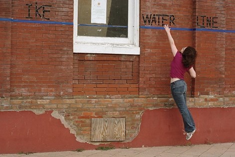
The water level marking on the structures like walls, poles or any surface where the color change due to the flood water is called the flood foot print. But if there are no flat surfaces, then the assessment of water level is through the damage it has caused. Hence the flood foot print is the water level marking at various places.
How to do the flood foot printing?
Every trailing foot prints have a ephemeral life. The clearing of the mess by revamping, reconstruction, refurbishments etc. will accelerate the expiration of this flood foot prints. In order to catch them when they are alive, immediately at the wake of the any major floods, all the districts, towns, cities devastated by the deluge need to be surveyed for the foot prints. The team of experts need to visit the places and make a noting on their records the Latitude- Longitude of the field of measurement and the water level marking from the demarcation it left on the walls by dirt and sediments. It is quiet easy to read these information from the structures that saw these floods. While doing these surveys, it becomes prime importance to draw a prominent marking on the structures that would last long for eg. a Lighthouse, a clock tower, a permanent pole, a stone walled permanent structure on a common place where it would last for ever/long.
Why is the foot print important?
Every forecast is based on certain theory and every theory is based on authentication from experiments and every experiment depend strongly on good measurements. Hence for any analysis the cross checking parameter would be these flood foot prints. I know how much myself and Dr. R. Rajaraman were ruing around for field measurement data to validate the tsunami modeling we did. However, to validate the flood and impact of flood modeling require these field measured data to fine tune and to validate for future forecasts. This helps a lot in the mitigation studies. This water level marking will also sensitize the local people to be prepared for any untoward incidents in future due to floods and also be warned of constructing any structures at lower elevations. A comprehensive data on water level markings (flood level -heights) on a vast area is a very good data for comparison and validation of analysis codes. This also gives a enormous confidence for the local authorities for the extent of flooding due to the rains. It must be noted that these markings will give a lifeline guide to the stranded people who are running for help to choose a safe area during flooding. They can understand clearly from the marked water levels where to run and take shelter safely. Further one must understand that these levels can also be retro fitted with the slow flooding models from the data set i discussed earlier (https://www.facebook.com/notes/joseph-winston-s/delving-into-the-deluge/10215025359086141/) . This would eventually lead to a reverse engineering work such as , from rainfall level in centimeter to flood water level computations. One must understand clearly here that there is no fluid mechanics model involved here, but only the Geo reference data and rainfall to flood level correlation only. This will make even any non technical personal who has a good statistical knowledge to start up the analysis and do accurate forecasting.
What are we to do?
**WARNING**
Have we done the task, field measurements? Have we reported the water level marking and recorded the same with respect to Geo reference in all Kerala districts? Have we documented this data with due respect through proper backup and archival?
IF NOT!
CATCH THEM BEFORE IT DIES!!!!!
As a learned society we must do it to save and protect us from future floods! Let us sensitize to have a state level Disaster Management State level- High level analytical team. Sensitize the town planning office to keep these records and centralize for all districts.
LET US SENSITIZE and ACT!
#Keralafloods; #Flood; #waterlevel
#FootPrints; #Flooddata #Floodanalysis
S. Joseph Winston (